Posts Tagged ‘GPS’

Updates for Diving Log 6.0 and Android released

Saturday, December 19th, 2020

I’m happy to announce two updates, one for Diving Log 6.0 on Windows and one for Diving Log on Android:

Diving Log 6.0 Changelog:

  • Garmin Mk2/Mk2i Support
  • SeacSync Import
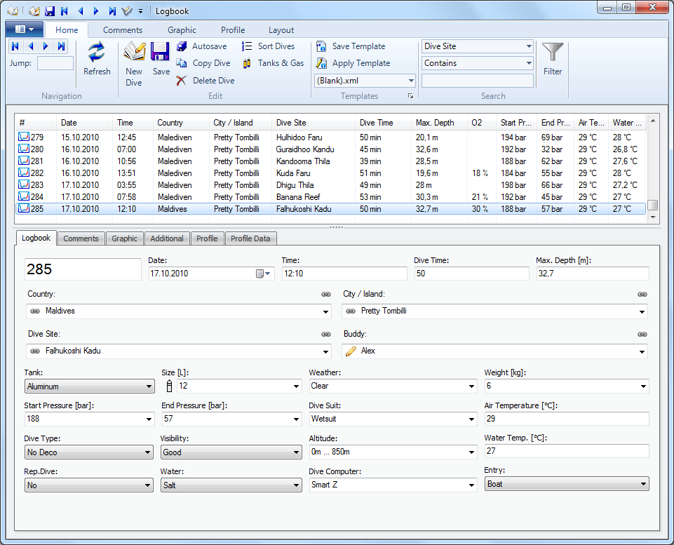
  • Tree Browser improvements (new: Shops/Dive Centers)
  • Dive Site GPS Import improved (Switch to Windows 10 API)
  • Map Window Navigation Panel (Windows 10 API)
  • OpenStreetMap and Divelogs.de sync issues fixed
  • Libdivecomputer Update (new: Aladin A2, Sherwood Sage)
  • Wlog Import .add file support

Diving Log Android Changelog:

  • Search Dives Function
  • Tree Browser (in App Main Menu)
  • Downloader: Sherwood Sage

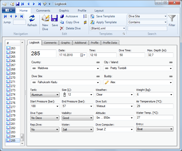
Diving Log 6.0 can now download dives from the new Garmin Mk2 via USB, including tank pressure profile data. The tree browser window shows now directly all dives with a certain buddy (without the location sub tree nodes) and has a new “Dive Shop” root tree item.

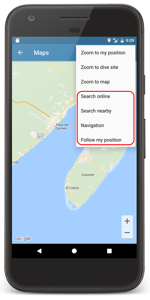
Diving Log 6.0 is now using the Windows 10 location API for capturing GPS coordinates for a dive site and also includes the navigation panel in the map window, which you may know from the Android app. Of course it requires an external GPS receiver, because most PC’s don’t have GPS build in.

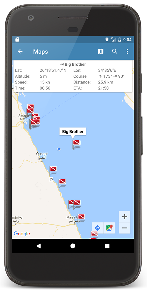
Capture GPS coordinates

Navigation Panel


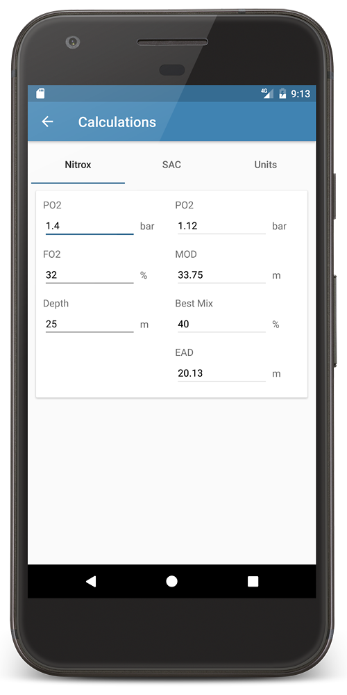
In Diving Log for Android you can now finally search your dives for certain values (numeric or string). You also have now the same tree browser functionality from the PC version.
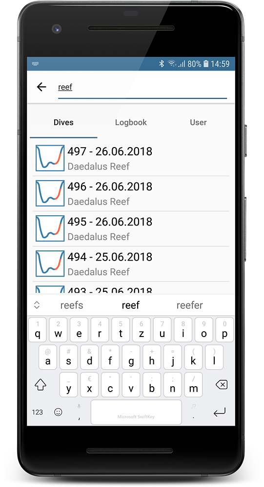
Search Dives

Tree Browser

Diving Log 2.0 for Android released

Sunday, April 9th, 2017

One year after the initial release of Diving Log for Android, the latest update has finally reached feature parity with the Windows Phone version. You will find in the latest update the following improvements and new features:

  • Map navigation panel
  • Online dive site search
  • Nitrox, SAC & Unit Calculator
  • Android 7 split screen improvements
  • GPS coordinate capture improvements
  • Bug fixes

The map screen has received some significant improvements. You can now activate a navigation panel, which shows you your current position, speed, altitude and course. When you select a dive site flag you can see also the distance, target course, time to target and the ETA (estimated arrival time). This is useful if you’re on a dive boat and want to check how long it will take to arrive the dive spot:

New Map Features

Navigation Panel

The navigation panel is mostly useful for nautical navigation on a boat. To navigate to a dive site on land, just select a dive site flag and tap on the Google route button at the bottom. This will open the Google Maps app and calculate a route to the selected dive site:

Select dive site

Route to dive site

You can now also search in the divelogs.de database for dive sites which are not stored in your logbook. You can either search by name or around a certain area by tapping into the map. Then you can import any of the dive sites into your own logbook file. And last but not least I’ve added the Nitrox, SAC and unit calculators to the Android app:

Dive Site Search

Calculators

Android 7 offers a new split screen function and I’ve improved the compatibility of the Diving Log app for this feature. It should now work just fine in split screen mode on phones and tablets:

Android 7 Split Screen Mode

Diving Log 5.0.14 released

Monday, September 1st, 2014

Today you can download the next update of Diving Log, which contains the follwing changes and improvements:

  • Dive Site Import (Google Earth, GPX, FlySight)
  • Cobalt 2.0 logbook Import support
  • Divesoft Freedom Import
  • Seabear Import
  • Scubase Import improved (more data tables)
  • Divers Book (iOS App) Import
  • Universal Downloader Update
  • New Chart Open / Closed Circuit
  • New Option “ShowAllGasLabels” in the report designer (Profile Properties)
  • Merge dive profile, include surface interval option
  • Google Drive and ownCloud Sync
  • Bug fixes

If you have version 5.0.13 installed, you can simply install the update setup. If you have an older version, I recommend to install the full setup instead (you do not need to uninstall the old version before). Here you can see some screenshots of the new features:

OC/CCR Chart

OC/CCR Chart

Import dive sites from various sources

Import dive sites from various sources

New Google Drive and ownCloud sync

New Google Drive and ownCloud sync

Diving Log 5.0.12 Beta 2

Saturday, November 2nd, 2013

Before releasing the next official update, you can try a new beta, which contains many minor improvements in several import functions and one long requested major feature. What’s new since the last beta from September?

  • You can now select the columns and sort order for the dive list (see below)
  • GPS coordinates are extracted from the Exif data from dive site photos (see below)
  • Android ScubaLog export improvement
  • The following import functions got improvements and bug fixes:
    • Liquivision Dive Log
    • UDDF Import (for xDeep Computer)
    • Shearwater Desktop
    • APD Inspiration
    • Suunto Dive Manager 4
    • MacDive
    • Universal Downloader

GPS coordinates from dive site photos: When you capture a photo with your smartphone or GPS equipped photo camera, the current GPS position is stored in the Exif data of the image. Diving Log will now automatically extract this information and store it into the dive site Lat/Lon fields (if the fields are still empty) as soon as you add a dive site photo. If there is already a position stored, the data won’t be overwritten by the data from the image.

Photo with GPS in Exif data

Photo with GPS in the Exif data

Columns and sort order of the dive list: This feature was requested for quite some time and now it is finally implemented. You can select the columns and sort order of the dive list in the logbook window. That means you can display your latest dive on top of the list and you can create a rather narrow list with just the dive number or a wide list with many columns, which spread above the dive details. You can use the layout editor to move the dive list around, to configure the columns and sort order, go into the menu File > Preferences > Dive List:

Dive List Settings

Dive list on top with many columns

Dive list with just one column

Dive list with just one column

Please download the beta now and let me know if you find any problems which should be fixed before the final release. Thank you!

Diving Log for Windows Phone gets SkyDrive Sync

Thursday, December 20th, 2012

This one is long overdue, but now SkyDrive is finally integrated into Diving Log for Windows Phone. The update should show up on your phone within the next few hours. You’ll find SkyDrive now integrated into the sync page, which means you could drop Dropbox – if you want so (SkyDrive is also integrated into Diving Log 5.0 on the desktop).

SkyDrive Sync Tiles

I’ve also updated the design of the logbook hub start page, to resemble the design of Diving Log Touch for Windows 8. If you don’t like the white tiles, you can switch back to the accent color tiles in the app settings. The last new feature is the same split GPS coordinate editor I’ve added recently to Diving Log Touch. This update runs on WP 7 and WP 8 (Windows Phone 8 optimized version will be released in January).

Diving Log Touch Update (version 1.2)

Tuesday, December 4th, 2012

While I’m working currently mainly on a new online logbook sync for the desktop version (more about that soon), I’ve completed another update for Diving Log Touch. It brings location and maps functionality, which is especially great on a tablet device. Diving Log Touch has now the dive site maps functionality, you already have in the desktop and phone version. It is using also the location service to capture your current position into the dive site details. Unfortunately most of the current devices don’t have GPS and just use WiFi triangulation, which is not very accurate.

Map of all your dive sites with coordinates

When you tap the new “Map” tile in the navigation bar on the main screen, you get into the new full screen map, which shows all your dive sites with GPS coordinates. When you tap on a dive site you’ll see the label with the name, tap again on the label to navigate into the site details. You can also search for dive site names and use the location service to get basic navigation functionality (distance to selected dive site, speed, course, etc.), similar to that function on Windows Phone on the right.

Editing of the dive site coordinates

When editing dive sites, you can now capture your current position into the coordinate fields. The lat/lon editor is now also optimized for touch keyboards with split text fields. The dive site view got also its own little map control, which just shows the current selected dive site. The view is interactive, which means you can zoom in and out and change the map mode. When you tap on the flag icon, it will navigate to the full screen map and zoom into the current selected dive site.

Diving Log for Windows Phone update

Saturday, February 18th, 2012

Today Diving Log 3.1 for Windows Phone has been released to the marketplace. It contains the following new features:

  • Search function for lists (dive sites, buddies, etc…)
  • Retrieve dive site coordinates from GPS
  • Buddy signature for dives
  • Dive site map
  • Navigation features within the map

Your buddy can now sign your dives on the phone and the signature will sync back to the PC. The signature will also sync to the iOS Dive Log and Dive Log Manager:

The integrated dive map experience will show all your dive sites with GPS coordinates (like the PC version). When you tap on a flag the name will be shown. Another tap on the label will navigate to the dive site details page. Additionally the map can show your current position on the map and calculate navigation data like speed, distance to the selected dive site and ETA (estimated time of arrival). You can pin the map right on your WP start screen and if you have a dive site selected, it will automatically zoom to that region. That way you can quickly access your favorite dive sites or the island of your next trip right from the start screen:

Tap on the new search button in the app bar to filter countries, cities, dive sites, etc. In the dive site editor, the position button will retrieve your current position and store it in the coordinate fields. The background color shows you the accuracy (red = bad, yellow = average, green = good):

Dive site maps support

Saturday, December 3rd, 2011

This is something on my own wish list for Diving Log for a very long time and I’m really glad that this is now finally included. You were already able to view your GPS enabled dive sites in Google Maps and Google Earth for a long time, but now there is also a build-in map experience which allows some nice things not possible in the existing mapping tools.

Map Overview

The dive site map displays all your dive sites with GPS coordinates from your logbook in the map. The search box allows you to quickly filter the displayed dive sites and the “Zoom Markers” button zooms and centers all displayed sites. When you right click into the map, you can add a new dive site at this position or update an existing dive site position (geo tagging). When you click on a flag, the dive site details window opens. You can use the scroll wheel on your mouse or two fingers on a touch screen for zooming (pinch-to-zoom).  And in future even more features will be possible, e.g. trips integration.

Add dive site to map


Two nice add-ons for Diving Log

Wednesday, September 21st, 2011

Today I want to show you two nice add-ons for Diving Log. Both tools were created by Diving Log users and add some great features, which are currently not available in Diving Log. The first one is “Facebook Uploader“, which lets you post any dive from your logbook to your Facebook wall. It creates a profile picture and uploads the picture together with some dive data to your Facebook account. Andrew Forget, the developer of this add-on, is looking for translators for other languages. Currently it is available in English and German.

Facebook Post

Profile Picture

The 2nd add-on is “GeoTag“, which lets you pick the dive site coordinates within Google Earth, or optionally extracts them out of a geo-tagged photo file (created by a GPS equipped camera). That is great for those who don’t have a GPS device or GPS equipped smartphone. Just open the tool and pick for any dive site in your logbook the coordinates in Google Earth. Thanks to René for this great tool!

GeoTag Window

Google Earth

You can add both add-ons to the “Tools” menu in Diving Log (GeoTag adds itself automatically when you launch it the first time manually). To add the Facebook Uploader, click “Manage External Tools” and then “Add” and naviate to “C:\Users\YourUserName\AppData\Roaming\Microsoft\Windows\Start Menu\Programs\AndyDragon Software\Diving Log Software”.

External Tools

GPS and new coordinate panel

Friday, September 10th, 2010

In my last post I’ve showed you the GPS Tool for Windows Mobile. Today I’ve released a new beta version of Diving Log 5.0 which adds GPS support and a new coordinate panel to the dive site window:

Full Setup (26 MB)
Update from 5.0.0 (19 MB)
Update from previous beta (2.4 MB)

When you click the new “GPS” button in the toolbar, Diving Log will retrieve the current GPS position when a GPS device is connected. If you have a Windows Mobile phone with GPS you can use the phone as GPS device for your PC (click here for instructions).

In this version you can switch also between several coordinate formats for latitude and longitude and view dive sites easily in Google Maps, Google Earth and Bing Maps. Please let me know how these new features work for you.

Dive Site Editor

Coordinate Formats